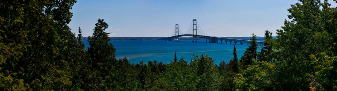
09/16/18
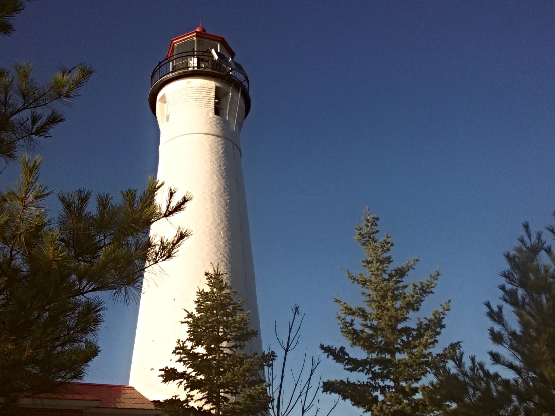
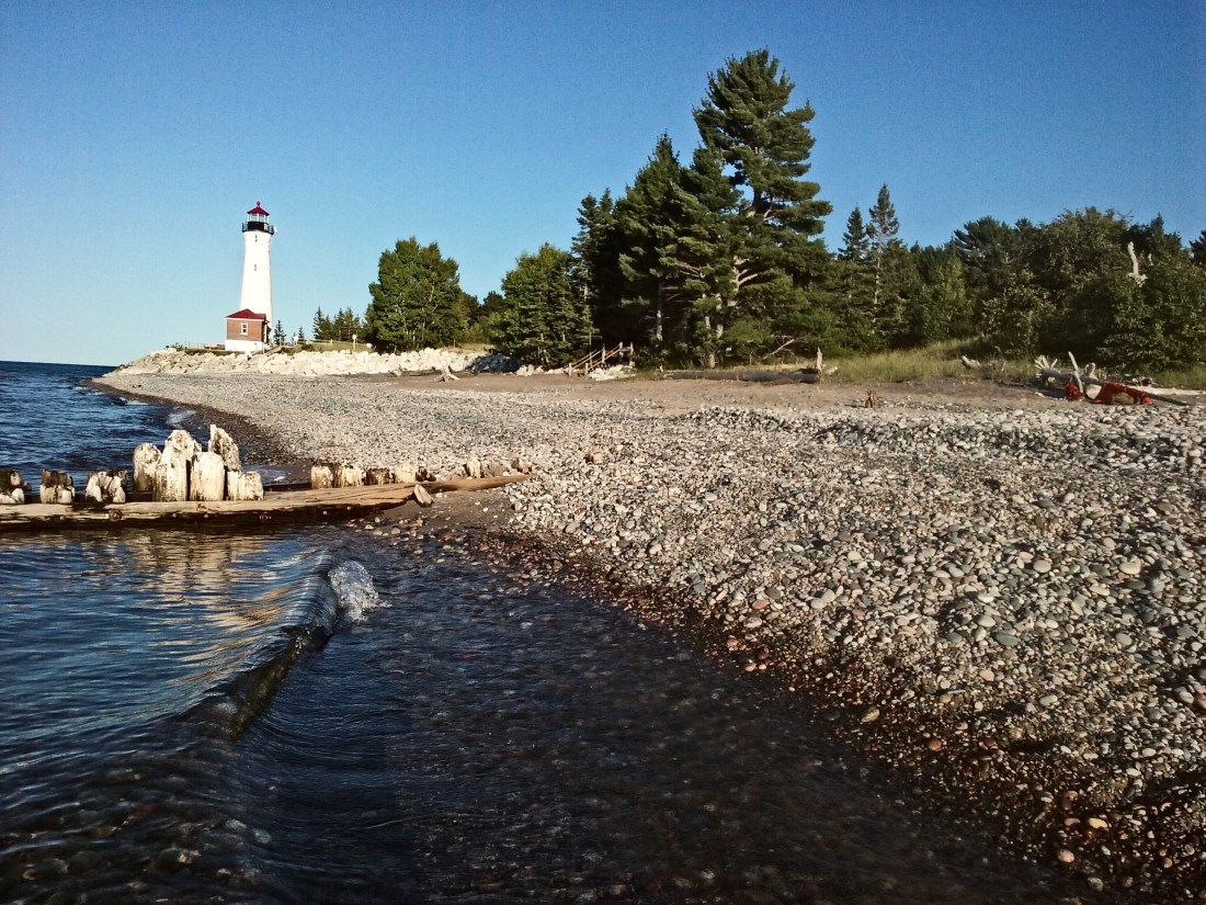
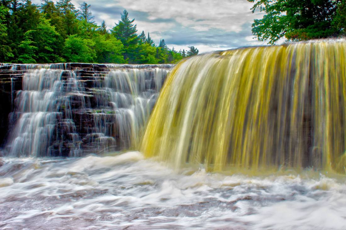
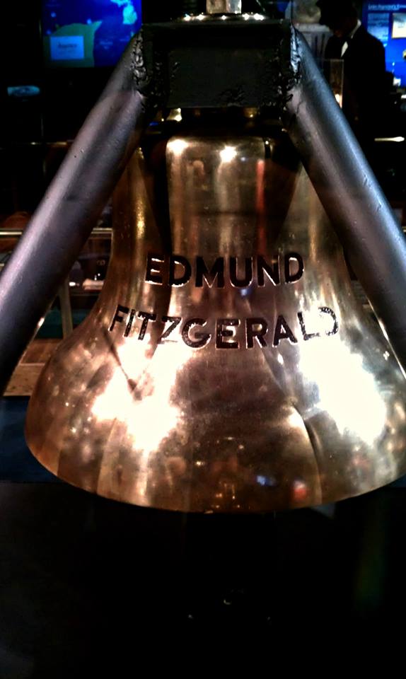
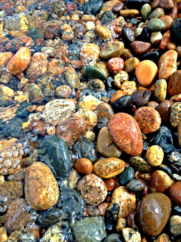
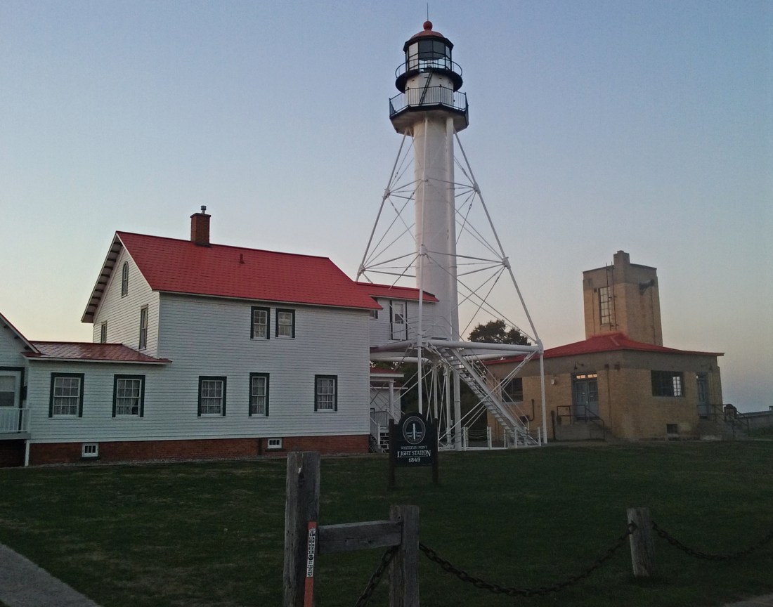
After last weekends successful rock trip, my mom and I decided another trip was needed. We’ve been wanting to go to Copper Harbor for some time now and that’s supposed to be a great place to find Lake Superior agates. However we only had three days and we just couldn’t fit everything we wanted to do in that short amount of time. It was decided we would head up to Paradise and spend two nights. We made a short list of food and other things and headed into town. We decided to pack a cooler and to make our lunches, rather than go out to eat all the time. We were in Walmart maybe a hour, I think we were both ready to get on the road. Came home, packed the cooler, loaded the car and headed out. Once we crossed the Mackinac Bridge we stopped in St. Ignace to pick up our dinner. We decided on Subway, quick and easy. After putting on some music for the road we continued our journey north. We arrived in Paradise around 3:00pm, the sun was shining and it was a nice 76 degrees out. We couldn’t have asked for more perfect weather. Mom found this quaint little “mom and pop” motel and that was home for the next two nights. After checking in and a much needed bathroom break, we headed to the lake to hunt rocks. We decided to go try our luck at the Whitefish harbor rather than the lighthouse. The harbor doesn’t get as many people except other rockhounds so we figured we’d have better luck. With bucket, shovels and a positive attitude we ventured forth to the cobble beach. There were a couple groups of people, some swimming others looking for rocks. There was one guy who had on waders standing out in the water scooping up rocks. Later he ended up walking down the shore and he found a very nice agate. I walked a ways down the beach bent over and squatted down, needless to say, my back and my knees were killing me! At the end of the day it was worth it because sure enough I found some. One time I took a much needed break to stretch my back, I turned around the face the lake and I was greeted by a freighter. Funny how that works, she was a bit too far out for me to catch the name but she was a Canadian boat heading down to the locks. I was a ways down the beach when I needed to use the bathroom, damn iced tea! So I start the trek to the little outhouse but along the way I kept looking for rocks and I even found an agate. Needless to say, I almost didn’t make it. We decided to head back to the motel to change, we were both pretty wet. After the car was unpacked and we got settled in our room, we got ready to head up to the lighthouse. There’s been a new discovery in the rockhound community. Rocks that glow while being exposed to UV lights, that;s why we needed the flashlights. These rocks or “Yooperlights” as they are referred as have exploded all over the internet. Of course we because interested in them and just had to go find some. These rock were the real reason we went to Paradise. Arriving at Whitefish Point Lighthouse was a very ominous feeling. There were maybe 15 people there, and the sun was just finishing setting, giving the white tower a beautiful golden glow. Being basically alone at a lighthouse is an entirely different feeling. Especially a place such as this with it’s history and the many wrecks scattered in the bay. Walking along the beach to the north we came across “graves” for three of them men aboard the Edmund Fitzgerald. Wooded plaques containing the name, birth, picture and what job they preformed. Rocks were placed there by the many guest paying their respects and crosses placed on each mound of rocks from drift wood. We were standing just in front of these using our lights to check if any of them glowed when the bell started ringing. I’m not sure where this bell was, or even if there was a bell. Both mom and I heard it and it chimed for quite a while, and sounded very distant off in the woods. No sure what caused the bell sound but it was enough to raise the hair on our arms and we left that area. Could’ve been the bell ringing 29 times for each man on the Fitzgerald, we’ll never know. We didn’t find any Yooperlights that trip, just being there made it worth while. I walked down the beach a ways by myself just to listen to the waves fold along the shore. I turned my light off and I looked up into the sky. The Big Dipper was hanging low in the northwestern sky, Cassiopeia or the big “W” in the sky was right above me. I could’ve sat there all night and gazed up at the celestial sky. A freighter was even making it’s way up the point. Her lights on, the faint humming of the engine slowly getting louder between the waves hitting the shore. I’ll never forget those five minuets I spent looking at the sky. It’s amazing what’s out there to see if you simply look up. After calling it quits we made our way back to the motel room where we had our Subway from earlier. We were both tired and sore, called it an early night in preparation for the following day.
09/17/18
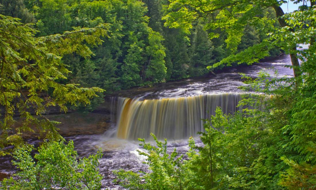
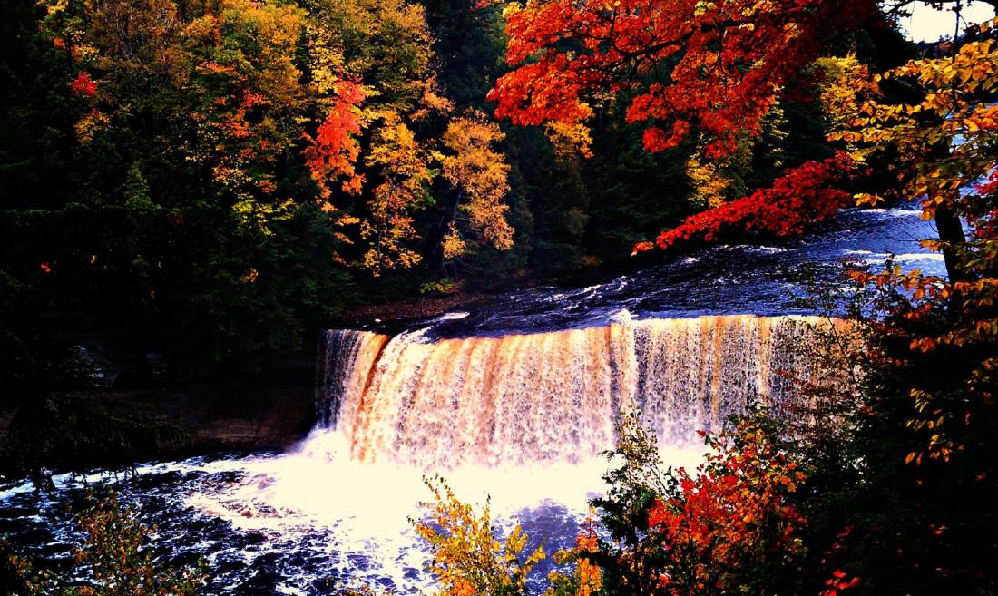
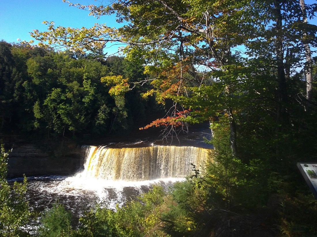
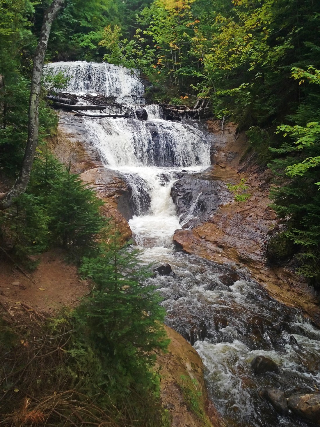
Waking up on Monday I was a bit nervous, there was a high chance of rain for the day. I walked outside and although a chill was in the air, the sun was shining and not a cloud in the sky. Today is going to be a great day, I told myself. We ate a muffin a piece for breakfast to hold us over for the morning. I packed us a cooler full of sandwiches, grapes and drinks. After showers, we were ready to hit the road for another day of rock hunting. Mom said she would like to stop at the Upper Falls ( see my Tahquamenon Falls entry) so that was our first stop. Now I’ve been to the falls a number of times but seeing it first thing in the morning is a sight to behold. That first view of the falls was enough to take my breath away. A nearby maple tree holding one of it’s branches as if to form a frame of leaves for the falls to sit within. The falls glowing in hues of white, yellow and brown. The towering pines above the falls glowing like jagged emeralds. The rising sun in the east acting as a spotlight reflecting off the tumbling water. We continued to head closer to the brink of the waterfall. Mom’s back and leg were having an alright day and allowed her to climb down the stairs. We took in the view, got misted and took some pictures. I climbed down off the viewing platform and took my sandals off and waded out into the river above the falls. The river was flowing warm around my legs and fell right in front of me. After I took some pictures and back on the platform we climbed back up the steps and back toward the parking lot. We did some quick shopping in the gist shop end ended up with a small bag of goodies. I grabbed a drink for both of us from the cooler in preparation for the drive ahead of us. Crisp Point stood out to me when we were up there the previous Sunday, we were going back. That also meant driving down that road again ( see my Crisp Point entry). The trip wasn’t bad this time, the road was a little washed out in a couple spots but it went quick. Mom was talking about some of her childhood memories: hide and seek, snowmobiling, Christmas. I know it brought a lot of happy memories back to her and she was smiling the entire time she was talking. She need that, get her mind off of things for a bit. It’s true when people say the beach is the best kind of therapy, it eases your mind and your soul. We got to the lighthouse and we were surprised at how many people were there, the parking lot was full. I immediately got excited because this is where I had good luck finding agates last weekend. With a bucket, small shovel and high spirits we headed to the shoreline. There was a group of fellow rockhouds looking. There was one guy who had on a wet suit and rubber knee pads down on his hands and knees looking. I told you people get into it! I thought to myself I’ll walk on down past them to start looking, they were all in a small area. I walked the beach quite a ways, taking breaks to stretch my back and knees. I found a couple down that stretch. I took one I was questioning to the guy in the wet suit, sure enough it was an agate. The wind was picking up so we took the opportunity to go eat our lunch. After lunch was polished off and I put on my mid knee mud boots we headed off to the opposite side of the lighthouse. This side had more people down it looking but I was feeling pretty optimistic. Since I had on my mud boots I walked a little further out in the water. I found quite a few agates down the beach but none that really stood out, I was still on the lookout. I passed people and they asked if I had any luck and that gave me a chance to show them off. A lot of people don’t even know what they are looking for. I’ll explain to them what an agate is and what to look for and again show them mine. After about five hours of looking we decided we had enough. I was going to walk the beach down to the area where I found a pretty one last weekend. Sure enough my eyes caught a pink band hidden beneath the rocks sitting on top as if to hide it, protecting it from the untrained eye. I reached down to grab it and profanity was ejected from my mouth. I’m really glad no one was around me to hear that. I held in my hand a beautiful agate with a bright pink banding design encased in a band of clear quartz around the entire rock. I found my first agate that truly amazed me. We headed back toward the car, I needed to get my boots off. I made the mistake of not wearing socks and I have a couple spots on my foot rubbed raw from the rubber eating away at the skin. Once i had my sandals on I wanted to check out the gift shop before we left. Inside was various Crisp Point attire, stickers, photographs and even a phone case. Located in the back of the shop are two display cases containing Lake Superior agates. One agate had just a sliver of it’s outer shell cut to show what was hidden inside. Bands of all shades of orange and copper were encircling one another as the lines danced on the rock. Also inside the gift shop were the volunteering lighthouse keepers. A couple from Wisconsin who every year make the trip to Crisp Point to do their part. I could’ve stayed there until after the sunset and talked to them. They actually told me some history of the lighthouse which was really interesting to learn. Turns on on the property there use to be two cemeteries. As Superior began to raise the cemeteries were eventually washed out. They say Superior never gives up her dead and she wanted the men she took back. The cemeteries sat where the shoreline is today, kinda weird to think about actually. We exchanged info so mom and I could find her on Facebook. After goodbyes were said we loaded up the car to head back to Paradise. Funny how that works isn’t it? A group of strangers who share similar interest and conversing as if we’ve known one another for years. Again the miles seemed to melt away along the dirt road, before we knew it we were on US-123. We decided to stop for dinner at a restaurant in Paradise called The Inn. After a quick five minuet wait we were seated, ordered drinks and looked over the menu. We both ordered the chili cheese fries and mom got a side order of jalapeno poppers. All their food is homemade, even the ketchup. Once dinner was finished and our bellies full we took the long commute back to the room, it was just across the street. Getting back to the room at an earlier time gave me the opportunity to get some reading squeezed in. We also planned what we wanted to do the following day. After talking to some people at the lighthouse , we decided to head to Grand Marais. Neither of us have ever been there so we said why not. We gathered all of our stuff together, packed up the cooler to make it easier to load the car in the morning. With that we headed to bed full of anticipation for a day full of new adventures.
09/18/18
I awoke on Tuesday wide awake, when I go some place new I get very excited. We had the car packed and were on the road by 9 A.M. The low tire pressure light came on so we had to stop at the gas station and fill the tires up. All the bumps from yesterday must have done their fair share on the tires. Aired up and good to go we ventured forth, next stop Grand Marais? Nope not quite, Newberry Michigan’s moose capitol was the next stop for gas. I put 20.00 bucks in while mom went in to get a coke and apparently a bunch of incense also. She walked out with a bouquet of all different scents. Gassed up, car now smelling good from the incense, our next stop was now Grand Marais. From the motel, it was about a hour and a half drive. The weather wasn’t the best, a very thick cloud covering kept the sun from shining. The temperature was in the mid to low 60’s so it was defiantly a day to bundle up, especially if we were going to walk along to lake to look for rocks. It’s a beautiful drive to Grand Marais, the road is nice and curvy going through a thick forest. Reds, oranges and deep burgundy were scattered among the many shades of green, signs that Autumn is slowly approaching. Lake Superior eventually came into view sitting right above the tree line as we came out of a turn. Grand Marais shortly followed as the road started to descend getting us closer to water level. Grand Marais is a quaint little town with main street going right through the heart of town with various business on either side of the street. Continuing through town the road let us to a place to park to walk down to the lake. Walking down to the beach was a shock of how chilly is was outside. I made the mistakes of wearing my hiking boots. No sooner was I down there and they got wet, Superior got me with a wave. Mom was in the same boat, her shoes got soaked. Back to the car to get the rubber boots! Making the journey back up the beach, we walked quite a ways down, was the realization the beach was filthy. Garbage followed by garbage, every step I took I could look down and see it. Either thrown there or forgotten, neither of those are excuses. It’s such a same this is happening. These are our lakes, lets strive to keep them beautiful. Walking the beach if you see a piece of trash or really anywhere, take the time to pick it up. Be courteous of Mother Nature and let’s keep her clean. After I was changed into my boots and I had mom’s hot pink ones in my arms, it was time for the hunt. We had some luck, was a bit too bitter out to look. I did score a baseball size quartz. I noticed from across the bay a lighthouse, that was our destination. We turned onto a road that led us north west out of town and into the far eastern end of Pictured Rocks National Lake Shore. We immediately saw a sight for Sable Falls. With both of us being water fall chasing, this was a must stop. The water fall is located just off the road, park in a decent sized parking lot and walk the trail east. As soon as you get on the trail you can hear the sound of what appears to be the sound of leaves being blown by the wind. Turns out, that’s the water fall. #Fooledbynature. After going down about 30 steps you get the first sight of it. The stairs turn into a hexagon platform and the trees open up to provide a perfect window for the falls to stand in. It’s a lot bigger than I expected. The three tiered falls stand an impressive 73 feet. After been taken back by the view, I snapped some pics, and we continued down the stairs. The next platform was further down the falls. From here I really got to see just how big it was. The pure white water tumbling down the sandstone cliff. Tier after tier until it finally empties into a little stone whirlpool before continuing down the river.
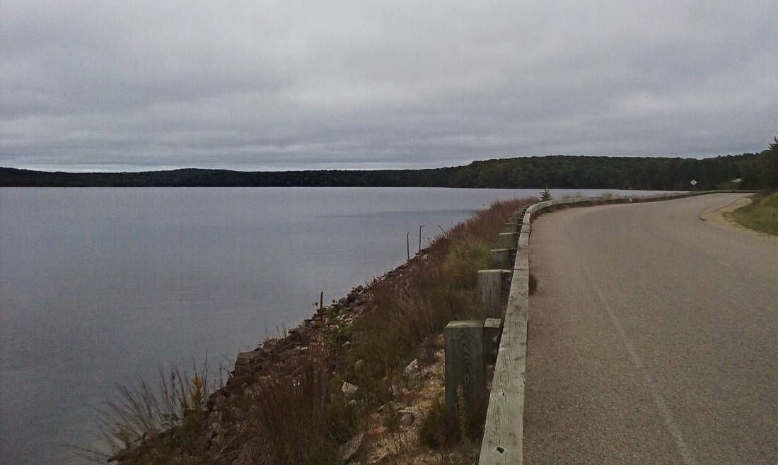
Leaving the falls we saw a sign for a visitors center, we decided it would be a good idea to stop and pick up a map. Located across the street from the visitors center was a backpackers trail head parking lot. My goal for next year is to hike Pictured Rocks. Once inside the small visitors center we were greeted by a park ranger and found out the only way to reach the lighthouse is a mile and a half hike. Mom said she wanted to do it so we could cross another lighthouse off our list, no matter how bad her leg and back felt. It’s for these reasons why she is one of the strongest people I know. Not many people will be willing to do that with four bulging disks. Lower Hurricane River campground was our next destination, but just like the waterfall other stops interested us. We rounded a corner along the road and Grand Sable Lake appeared in front of us. The surface as smooth as glass, the trees standing along the shore being perfectly reflected in the water. Saw our first sign of wildlife here too. A cormorant was standing on a tree that fell in the lake some years ago drying it’s wings. We pulled over and I spooked the bird when I opened the car door. It flew off skimming the water with it’s feet still touching the surface as if is was water skiing.
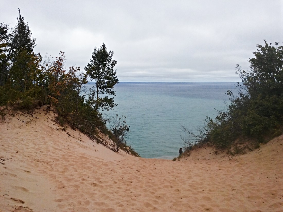
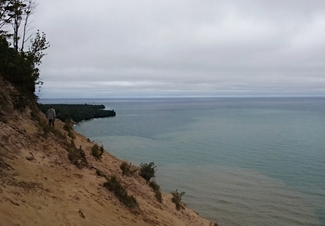
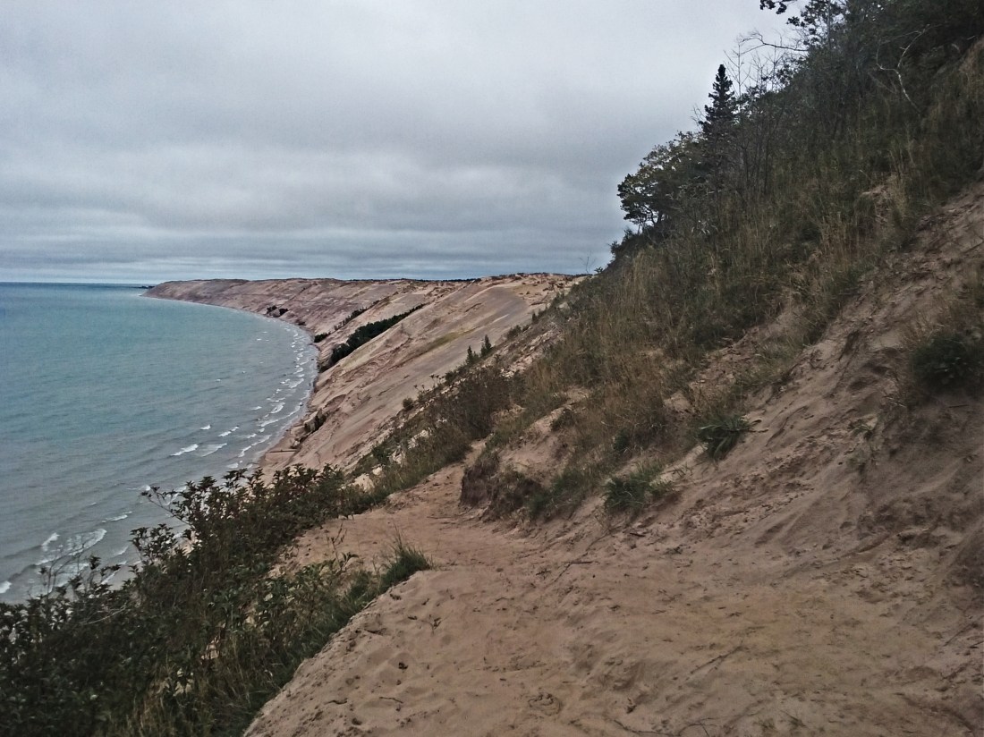
With the lake fading in the rear view mirrors the road continued to rise with each curve. Eventually we made out way to the Log Slide overlook. I’ve heard about this place for quite sometime. Nothing could have prepared me for what was to come. From the parking lot it was a quick quarter mile hike. Along the way you get a brief history of the location. In the late 19th century loggers used the natural sand dunes as a quick way to get the fresh cut lumber down to the water. Once there it was a lot easier to transport to it’s destination. The forest we were standing in is actually all new growth. Before being cleared out jack pines stood tall, now mostly a deciduous forest thrives. The path changes from a packed down dirt trail to loose golden sand. Small dunes on either side with it’s beach grass hair growing a top the many mounds. The sandy trail climbs up the back of one of these dunes, with each step Superior beings to come more into view along the horizon line. Once I made it to the top my mouth fell open as I took in the view. I was standing at the top of a 300 foot sand dune with nothing but Lake Superior in front of me. After I stood there taking in the view, I looked to my left and I could see the lighthouse, standing proud among the green trees. A couple who were also taking in the sites climbed a little ways out to the right and I decided I wanted to do the same. The sand was actually really packed down, which made for a nice path. I walked past the couple and stood on a perfect little platform and I gazed to the east. Yet again my mouth fell open, when my eyes focused I saw nothing but sand sloping down to meet the lake. For miles, that’s all you can see in colors of tan and pink. I ran back and told mom she needed to walk out there. From the top of the overlook you can’t see whats hidden behind the close sand dune shielding your view. After helping mom to where I was standing, she too was taken back by the view. I’ve been fortunate enough to see some beautiful places around this state. Standing there on the Grand Sable Dunes overlooking Lake Superior will be forever imprinted in my memory, truly a beautiful place.
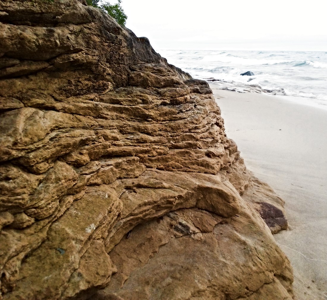
Once we finished up at the dunes, it was time to head to the lighthouse. We continued down the road that was gradually taking us down to the lake. We got to the campground at parked at the trail head for the lighthouse. With both of our stomach rumbling, we took the opportunity to grab some lunch. We sat right in the car and ate, Lake Superior was visible through the tree line. The parking lot was packed, a lot of day hikers on the trail. I never realized where all the North Country Trail goes, it makes me want to hike it. With our bellies full we walked down to the trail and started our hike. We came across outhouses and as a precaution I took the opportunity and used it, now it was time to hike. The trail was very well taken care of, nice and smooth. We passed by Lower Hurricane River campground. Looked like a nice place to camp, you can hear the lake from the sites. Following the lake shore we ventured forth. We passed quite a few hikers along the way. Along the hike the trees opened up providing views of the lake. Superior was angry, her waves hitting the shore and crashing hard. The shore line was very interesting. Beautiful sandstone cliffs protruding from the tree line appeared as a stack of pancakes. Layers and layers from the water hitting it and slowly washing it away. I was being adventurous and went climbing on the formations. I thought I’d be safe because I chose to stand on an area that was dry, nope. Protective Superior got me, my boots got wet but all in good fun.

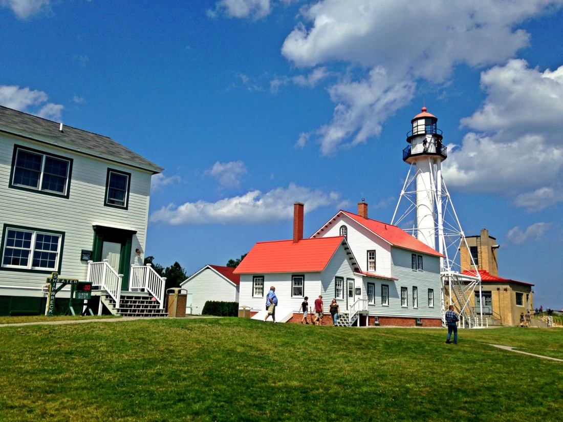
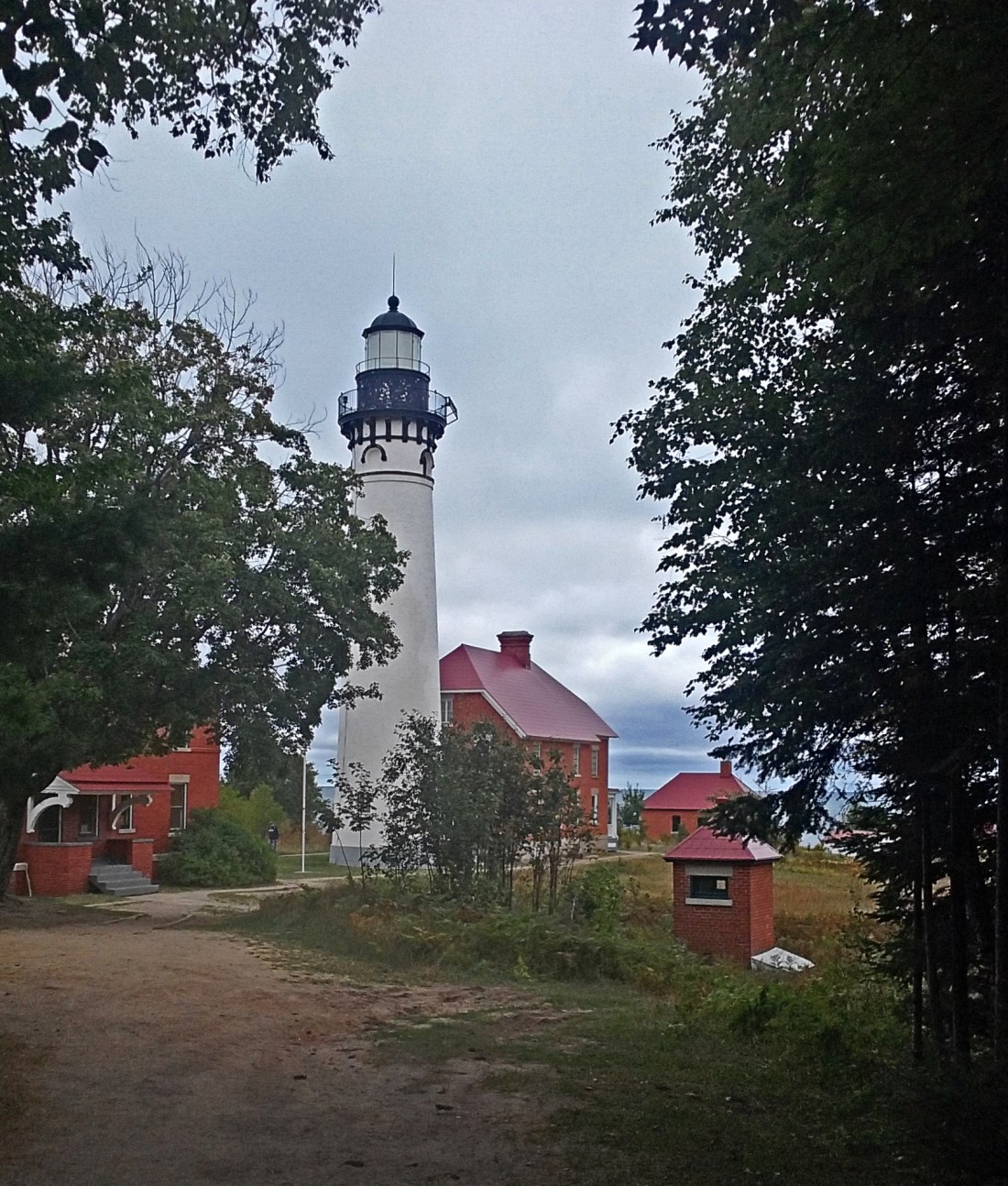
At one point in the trail, stairs will lead you down to walk the back to a shipwreck. I walked down there buy it was a 1500 foot walk and I didn’t want to get wet and leave mom standing there. Next time I’ll go see that. Along the trail there were various streams that would go under the trail and empty into the lake. Mostly small streams, we came to one that was pretty decent in size. Being the rockhounds we are I went down to look through the rocks. The river had coated them in brown algae, slimy to the touch. I didn’t want to get my hands all gross. It was after that stream the trail curved as the tree line got thicker sheltering us from the wind off the lake. Up ahead in the distance there appeared to be a clearing with, what I thought to be a sign in the middle of the trail. Turns out that was the whitewashed lighthouse tower, growing wider with each step we took. Approaching the tower the top came into view and I was surprised at just how tall it was. The 87 foot tower with it’s black trim and black lantern room stand guarding mariners from the shallow sandstone reefs in Lake Superior. The attached lighthouse keepers house is all red brick with a red shingled roof. The contrasting colors really make this lighthouse unique. Sadly we weren’t able to go inside, I don’t thing you can climb it either. One of the first things that caught my eye was how rundown the tower was. One of the windows was covered by a piece of plywood. The black paint up on the lantern housing was chipping away. We explored the grounds for a bit, walking to the eastern most side gave us another view of the sand dunes off in the distance. Snapped some pictures, sat on the steps and took a break and we started heading back to the car. The hike back went a lot quicker. We came to another opening in the treeline and mom said she would like a small piece of sandstone. Off exploring I went looking for some pieces that stood out to me. I loaded up my sweatshirt pockets and again was just mesmerized by the view. The shoreline from Grand Marais all the way to Munising is considered to be on of North America’s most beautiful, I can see why.
Once back to the car and my pockets emptied into the bucket of rock we’ve collected, we decided to make the journey back home. The trip home went surprisingly quick. Both mom and I were exhausted after such a busy weekend. When we hit Newberry we stopped at McDonald’s for a much needed coffee break. Once the caffeine hit we were both really talkative and we were talking about some of the highlights from the trip. We stopped in St. Ignace for dinner at the Truck Stop. I had a wet burrito and mom had a chicken taco salad, we were both craving Mexican food apparently. With our bellies full once again we headed toward the Mackinac Bridge. I’ve been across the bridge many times and crossing it on that Tuesday evening has to be at the top of the list. The sun was just starting to set. The bottom of the sun dipping behind the horizon line, the golden glow of the sun creating a path on the surface of the water. The sky all lit up in deep oranges and yellows around the sun. Orange eventually became a nice warm pink color until that faded out to a very light blue. Dark blue and purple clouds as if placed there to break up the colors. It was one of those sunsets that no matter how hard i try to describe it, it’ll never do it justice. To top it all off a freighter had just passed under the bridge heading west to case the setting sun. Riding right in that golden path the sun was making, as if to show the freighter where to go. A perfect sunset to close our trip as the Lower Peninsula and home came into view.